Introduction
| Mendum's Pond (1998) |
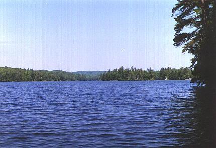
Mendums Pond is located on Hall Road off Route 4 in Barrington, NH. A portion of this area is designated as a recreation area by the University of New Hampshire . Mendum's pond contains 187.6 acres of forestland, including two beaver
ponds. It is a nice place to take a swim, drop a canoe in, or just hike around and enjoy the abundance of wildlife.
History
In 1930, Arthur W. McDaniel donated a small parcel of what is now known as Mendum's Pond to the Women's Athletic Association of the University of New Hampshire. In 1970 he then granted the rest of the area to UNH for the sum of one dollar.
Present Use
For the last few decades UNH has used some of the shoreline property to house its Sailing Club. The rest of the property has been allocated accordingly: a recreation area, an active natural and wildlife area, and a timber harvesting area. The recreation area consists of a picnic area, canoe rentals, and a playground. Information about use of the recreation area should be directed to the department of Campus Recreation.
The most recent timber harvests occurred in 1998 and in the winter of 2015-2016 and 2018-2019. These initiated an ash reserve as part of a larger UNH-wide project and established research that looks at crop tree release and development over time. In 2011 permanent inventory plots were put in place here as part of the UNH Continuous Forest Inventory system. These will be a basis for future measurements and as a tool for researchers.
Directions
Take Route 4 West from Durham. Turn right onto Hall Road in Barrington. Travel .6 miles to the main access road which is shared with the Recreation Area. Parking along this access road or within the Rec Area parking zones should be arranged beforehand because you risk having the gate locked behind you. Alternately, continue on Hall Road another .2 miles to a gated pullout on the left for a recent log landing. If you park here please avoid blocking the gate.
Approximate location: 43°09'44.9"N 71°03'22.2"W