Introduction
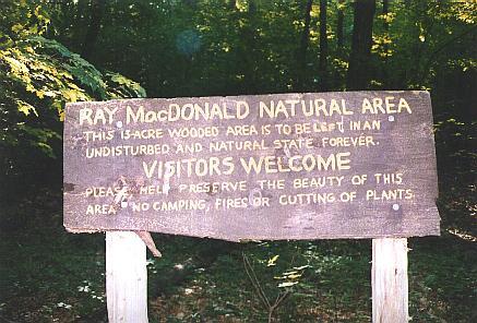
The Ray Macdonald Natural Area. This 13-acre wooded area is to be left in an undisturbed and natural state forever.
The Macdonald Lot is a 78.9-acre forested area that lies between East Foss Farm and Oyster River. Access can be gained through East Foss Farm, off of Foss Farm Road or from the end of Orchard Drive in Durham.
The Ray MacDonald Natural Area is a 13-acre portion of the woodlot that borders the Oyster River. The land was left to the University of New Hampshire in 1977 by Ray F. and Elizabeth MacDonald. The property was purchased by the MacDonalds as part of the Hamel farm. The land was donated to UNH to ensure that it was not subdivided and to prevent further pollution to the Oyster River.
Present Use
The MacDonald Lot is a valuable resource for the university. It contains one of the three natural areas that the woodlands and natural areas office manages. The plant community in the Macdonald Lot is diverse and it is extensively used for research and education by UNH.
In 2008 a series of replicated control treatments were implemented to reduce the population of glossy buckthorn, an invasive shrub that is a severe problem at MacDonald Lot. Following an additional treatment (in 2009), there was a timber harvest in those areas (in 2010). Since then, this experiment has served as a basis for several graduate and undergraduate research projects and as an increasingly rich resource for undergraduate laboratory classes. There have also been multiple field conferences for the larger forestry community that discuss harvesting and the control of invasive shrubs.
Directions
Take Mill Road in Durham southwest until you reach Foss Farm Road (just before you reach the bridge that goes over the railroad tracks). Take a left on Foss Farm Road. Take the next left on Orchard Drive and follow until the end of the cul-de-sac; park here. Follow the marked trail to the entrance of MacDonald Lot, a UNH sign marks the boundary of the property.
Approximate Location : 43°07'33.0"N 70°55'45.1"W